
First published on June 12, 2020 • Last updated on February 19, 2022
This page may contain affiliate links; if you purchase through them,
we may receive a small commission at no extra cost to you.
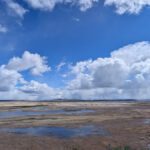
Across the valley from north Quito, looking out over the new airport, it is easy to see a set of jagged mountain tops in the distance. This is Cerro Puntas. When I originally wrote this article, I had lived in Quito for two years and each day that I looked at this stunning geologic feature, I wanted to visit in person and hike to the tippy tops. Unfortunately, getting there is complicated and the weather is not always cooperative. Therefore, I had to postpone the trip many times. It wasn’t until August 2015 that two friends and I took the plunge.

The Drive to Cerro Puntas Starts in Checa
First, start your drive to Cerro Puntas early. The entire journey will be a long one even though the exit from the main road is a short distance outside of Quito in the small town of Checa. With the new Ruta Viva, it should take you about half an hour to get that far.
Second, be patient. The route becomes more complicated and you will likely find yourselves asking for directions along the way. We recommend using a high clearance vehicle, at the very least, and a 4×4 to cover your bases. The road is dirt, gravel, grass, or cobble and hardly any of it is well-maintained. My friend and driver for the day thought it was better than our trip to Guagua Pichincha. I thought the road was much worse though we did not climb as high. Either way, driving to Cerro Puntas is an adventure! But this article should give you an idea of what to expect.
Third, plan on stopping a lot. There are opportunities for great photos around every bend.

Driving Directions To Cerro Puntas
As you arrive in Checa from Quito, you will see a small frontage road on the righthand side. Exit onto the frontage road and then turn right onto the small road in the middle, San Agustín. Drive to the next block where you will take a left turn onto Cerro Puntas.
Then you have an immediate choice – a y intersection. We took the upper road mainly because it was named Camino al Cerro Puntas and we figured it was the best way to arrive. However, we ended up coming back in a different way. That road, Avenida San Agustin, connected to this y intersection via the alternate route. Both roads will eventually get you to Cerro Puntas. It’s a 50/50 recommendation to go either way. They both have their pros and cons.


Cerro Puntas Road
Option one, the Cerro Puntas road is in slightly worse condition and the directions are not always clear. A few kilometers in, there is an old, dilapidated farm, the Hacienda Santa Teresita (black flag on the map). The gate crossing the road was locked on the day we arrived and the caretaker was unable to open it. However, he pointed to a side road that skirted the property and allowed us to go around and continue on our way.


Then, a few kilometers further, we thought we had dead-ended as the road lead directly to a farm compound with no clear exit. We actually found a place to park and decided to use this as our hiking point. Fortunately, a young man caring for the fields was willing to answer a few questions and told us that we would be better off getting back in the car and driving through the farm paddock to continue onto the road beyond.

Again, if we had arrived on a day when no one was working this portion of the property, we’re not sure we would have made it through. After this, it was just driving on a rutted dirt road. If we were offered a choice in road, we took the one most traveled and clearly seemed to be the correct direction to reach Cerro Puntas. Trust me, we’re not always the smartest in this regard but if we could make it, I think most people could find their way.


The Alternate Route
The second option seemed to be an unnamed back when we took this trip. At least, we never saw any street signs on our way down the mountain. It seems Google has since updated and made it easier to see this road is actually the same Avenida San Agustin we saw when we very first started this trip.
This alternate route seemed to be in better condition overall (still 4×4 recommended). The road traveled through a more populated area but, once again, there was a gate at the entrance to Hacienda Santa Teresita. Obviously their property is expansive and crosses a large portion of the mountainside. The gate was open the day we returned but if it would have been locked, there was no alternate path around the property. Though there are many farmworkers in the area to ask for help, the alternate road may not be the best choice.

There is also a second farm building (coming down, we actually saw it first) with a sign directing people towards Hacienda San Francisco de Asis. My research drew a complete blank and I can find no place with this name in this corner of Ecuador. If any of you know of the Hacienda and have more information, please let me know in the comments below.

A Google Map Warning
These dirt roads are not shown in their complete length on the Google Maps. As of this publication, the route is better marked to the Hacienda Santa Teresita and around back down Avenida San Agustin. However, it does not show the road going further up the mountain.
Furthermore, using the satellite view, it is easier to see where the roads meet near an old stable with a beautiful view of the valley below.
Good luck on your own trip. Please let us know how it goes!
Exit from E-35 to Calle Cerro Puntas
Look for this exit on the right-hand side of the road as headed from Quito towards El Quinche.
Y Intersection
This is a Y-Intersection. Both roads can lead to the trailhead at Cerro Puntas. We took the route leading left on Camino al Cerro Puntas and return on the Avenida San Agustin.
Hacienda Santa Teresita
This is the Hacienda Santa Teresita. The day we arrived, their gate was locked tight and did not look as if it has been opened for a long time. However, we took the small dirt road that veers off a few hundred meters before the Hacienda gates.
Y before the Hacienda Teresita
The easiest route is through the gate at Hacienda Teresita. However, the day we arrived, the gate was closed. Our solution was to take the faint track to the right at this point on the map. We walked a large part of it first to make sure it was suitable for our car. It allowed us to go around the Hacienda and intersect with the Camino al Cerro Puntas.
Paddock Crossing
This is the farm where we were going to park before a kindly farmhand offered us a route through a gated paddock. Google Maps currently shows a through road at the same point that did not exist for us.
Stable with View of Quito
Barn with view towards Quito. This is where we stopped and heard the poor, sick cow. Looking back at Google Maps, it’s hard to tell which of the roads got us here in the end. There are overlapping routes. But if you choose to go up the mountain rather than down, it is almost always the right choice.
Trailhead
This is the spot that we chose to make our trailhead. Several dirt tracks overlap in this area. The one leading up the mountain looked passable for bikes, horses, and people, but not cars. We could also see our goal and knew that it would be very hikeable from this point on.
Meeting of Camino al Cerro Puntas and Avenida San Agustin
Google Maps currently shows where the roads Avenida San Agustin and Camino al Cerro Puntas meet. This is the point where we stopped at the stable and took photos back towards Quito.


