
First published on July 7, 2025 • Last updated on July 7, 2025
This page may contain affiliate links; if you purchase through them,
we may receive a small commission at no extra cost to you.
We acknowledge that Punch Bowl Falls and Eagle Creek Trail, located in the lower Columbia River Gorge, lie on the traditional territories of many tribes and bands who have inhabited and stewarded this land since time immemorial. The lower Columbia River, known as Wimahl in Upper Chinook and Nch’i-Wàna in Sahaptin, is home to tribes including the Chinook, Clatsop, Kathlamet, Wahkiakum, Multnomah, Cascades, Tualatin Kalapuya, Molalla, Wasco, Clackamas, Cowlitz, Skilloot, and Atfalati. These tribes have ancestral connections to this region and continue to maintain a deep and abiding relationship with these lands and waters.
We honor and respect the enduring relationship that exists between these tribes and their ancestral lands. We pay our respects to their elders, past and present, and extend that respect to all Indigenous people today.
It’s late spring in Portland, Oregon. Scott and I stow our gear and head about an hour down the road to the Columbia River Gorge. We’re aiming to hike a local classic: the Eagle Creek Trail to Punch Bowl Falls.
We decide to leave a little after 7 a.m.—not to beat the heat, but to make sure we can easily park at the trailhead. Even midweek, this popular trail attracts both day hikers and backpackers, many striking out to Tunnel Falls, about 12 miles round trip, or to complete the entire trail to Wahtum Lake, about 25.5 miles round trip. And it’s a good thing we left early. By about 8:30 am, there are only a couple of parking spots left.

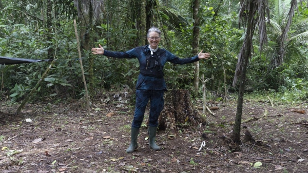
Birdsong greets us as we hop out of the car. I strap my camera to my chest harness, pack a little more gear than I need into my Wy’east backpack (training for our upcoming trip to Peru), and grab my trusty hiking poles. We’re expecting to put in about four miles round trip today.
The sun is shining, and since the trail hugs the left side of the creek, we start in the shade. Song sparrows and Swainson’s thrush compete with the calming sound of rushing water coming from Eagle Creek. The surrounding forest is lush, the low growth so green that it is almost easy to forget that this area suffered from an extreme fire in 2017. However, the scars still exist, with the stark grey trunks of dead trees reaching skyward and the occasional giant Douglas Fir, dark with char, standing sentinel along the trail.


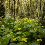
June is a beautiful time to hike this trail. We spot a noisy Stellar Jay, its deep blue-black feathers well camouflaged in the dark canopy of the trees. And soon after, we spy a gorgeous Red-breasted Sapsucker, quickly passing on its way through the forest. The wildflowers run riot – from sparkling white Lewis’ Mock Orange to delicate pink wild roses, bright yellow Monkey Flower to royal purple Brodiaea Coronaria.


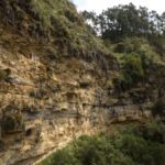
The trail slowly climbs, a fairly even rise in altitude. With all the things to look at, we hardly notice how high we’ve climbed. But then I look to my right, down slope, to the creek far below. I’m glad that the trail is so wide.
Then we arrive at a steep, rocky section. The trail narrows, the hillside drops away completely, and cables drilled into the mountainside for handholds tell us that the next section might get a little dodgy. It is certainly not a place I want to meet hikers coming down while we are climbing up. Fortunately, we are early enough that most people are merely passing us on the trail. The odds of running into someone are fairly slim.

From this point, we notice more water rushing, cascading, falling off the mountainsides to reach Eagle Creek down below. We can hear the creek more easily than we can see it. When the water begins to roar, we know to search for a waterfall on the other side. It’s not yet Punch Bowl. Maybe Salmon Falls? Scott ponders, remembering an article he read about the trail. More likely Metlako Falls, as they appear at the right place on the map.


At the bend by Sorenson Creek, the neatly built trail allows us to hop across without getting our feet wet. We see a massive, fallen tree, its roots tangled and exposed to the air, likely a delayed casualty of the last fire. Not all fire damage is immediate. Often, a fire burns roots underground or weakens a tree, making it susceptible to rot or infestation.
Hiking this trail makes me thankful for our US Forest Service employees. Part of their job, when fully funded, is to maintain trails like this one. With each trip out to the Mt Hood National Forest, I wonder how much longer we will have unfettered access, especially if Republicans in Congress continue to search for ways to sell public lands.

We continue hiking, admiring the lacy green licorice ferns with their solid black stems, and stop to listen to the birds once again. Scott sees a Red-breasted Sapsucker before I can manage to train my binoculars in the right place. It’s already flown away. And then, we arrive at the decision point. Down to the lower Punch Bowl Falls or further along the trail to the viewpoint? Which picture do we want the most? Will I have enough energy to do both? Hiking with MS always makes me second-guess my abilities to finish a trail.
We choose to hike down. I want to dip my bandana in Eagle Creek and feel the cold water on my fingers. I want a picture of the waterfall head-on because, in all the articles we read, I saw only shots from above.
The trail quickly gives way, dropping rapidly but never too steeply until we hear the small cascade of lower Punch Bowl. The trail barely allows us a peek-a-boo view before we break out onto a stone-strewn beach, a wide shallow creek, and cliff sides covered with moss. Cliff swallows swoop and dive, catching high flying insects overhead. Another hiker is sunbathing while their companions walk across a log bridging the way to a potential view of Punch Bowl Falls. Maybe I will get there yet.

Scott heads over first. I need to conserve my energy, and it isn’t worth crossing if I can’t see Punch Bowl Falls. He balances so carefully at the end of the log where it just falls short of meeting a rock on the other shore. He bounces slightly as he prepares to jump off, a feat I am loath to repeat. I hate heights. I hate jumping. I hate walking on logs.
In fact, I hate all of these things so much that even as Scott climbs the hill on the other side and sends me a thumbs up, that yes, we can get the photo I want, I hesitate. I stand up to ready myself to clamber onto the log when fear begins to take over. My heart is beating too fast. I have a hard time finding my breath. I am bombarded by the many times I have faced difficulty on the trail – struggling with altitude on Dead Woman’s Pass, feeling unable to climb one more step to see the sunrise behind Reventador, limping out of Laguna Culebrillas with a leg that just refused to work. These flash through my mind in mere seconds.
And in the strange way that minds sometimes work, I hear my friend Margarita reminding me to breathe. That single breath floods my mind with memories. I finished the Inca Trail, I saw the sunrise, and I managed to survive the hike to Ingapirca despite my bad leg. I can walk across a damn log.

Using my hiking poles for balance, I delicately make my way across. Halfway, there is a large stone stuck in the creek, easily reachable from the log. Past this point, the log narrows to the point at which Scott bounced off the end. This is where I have to change tactics. My heart may want to walk across, but my mind fears falling and I picture myself lying in the river below, hitting a rock with my hip, unable to rise.
Instead, I sit astride the log, use my arms to lift my body up an inch or two, swing my butt forward, sit again. I repeat this for the remaining four feet or so, grateful that my arms are strong enough to keep the rhythm going. I may look like a fool, but I won’t be falling in the water today.

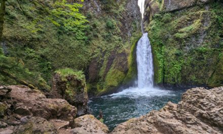
I’ve made it to the other side. Now all that is left is to find the view. I scramble up the fallen rocks, finding a hidden staircase of ancient basalt rocks leading to the highest point. And there, across a log jam at the narrow point, I can see Punch Bowl Falls.

It is beautiful. It’s as if an ancient potter has molded clay into a bowl with a lip for the creek to descend. The basalt stone walls are mottled with light grays and whites, gently weathered from years of use. It holds water so clear that it reflects blue from the sky, green from mossy forest, creating layers of colors that shift and change in the morning light. The waterfall itself is so white that it demands the spotlight.
From this distance, this is a gentle waterfall; the sound of water hitting water soothes and comforts. It beckons. I am tempted to try and find an approach but I know my limits. I still have to walk back across that log, scramble up to the main trail, and hike back. My heart wants to do more. My body says enough already.
Be content. Be satisfied. And I am.

After scrambling back across the log, completing the passage in reverse (arms, butt, arms, rock, stand, balance, back to the otherside), I dip my bandana in the cold water, wring it out and wrap it around my neck to help keep me cool for the hike back. We watch an American Dipper as it flirts with the water, perches briefly, than heads off towards the falls.
The trail out is full of wonders as well. Brilliant blue butterflies on the water’s edge. A vibrant orange tiger lily that belongs in a garden surprises us. We hike the tiny bit further out to see Punch Bowl Falls from above. At the actual viewpoint, the waterfall is hidden from view by vibrant, green leaves of vine maple. But a tiny bit further up the trail, the view opens wide enough for a single person to stand and photograph, looking almost straight down. I’m happier still that we took the time and made the effort to admire this beauty from creek level.


")
As we hike back, we pass many more people coming in. We’re fortunate not to meet people on the narrow part of the trail. And we make it back, hungry and ready for our picnic lunch. Somehow, we’ve managed to spend an entire morning hiking out and back, averaging a little more than an hour a mile – almost a 5-mile round-trip hike, including the detour to the lower falls. I’m tired but happy and thankful for the time spent outdoors.
Information for your hike to Punch Bowl Falls
Photography: Photographing Punch Bowl Falls from eye-level requires going to Lower Punch Bowl Falls (more a cascade than a fall), hiking across the creek (depending on the depth, you will either ford or use a log), and then climbing up some steep rocks on the other side. You may be able to approach the falls for closer views but plan on bringing a dry pack for your gear as you may need to hike through deep water to access the beach past the log jam. (see pictures above).
Hiking Distance: The hike from the Eagle Creek Trail Head to lower Punch Bowl Falls and back is just shy of 6 miles, according to our e-Bird map.
Eagle Creek Trail Head
Punch Bowl Falls, upper viewpoint
No Car? Consider getting the Gorge Transit Pass. With it, you can take unlimited rides with Columbia Area Transit (including the Columbia Gorge Express and the Gorge-to-Mountain Express), Link Public Transit, Mt. Adams Transportation Services, and Skamania County Transit, connecting the Columbia River Gorge on both sides of the river to Vancouver, Washington and Portland, Oregon.
Parking & Permits: The Eagle Creek Trailhead is located on US National Forest land, so a valid Northwest Forest Pass or equivalent (like an America the Beautiful pass) is required for parking. We recommend purchasing a pass in advance, as many trailheads in the Columbia River Gorge, including this one, do not offer on-site purchasing options. Passes can be bought online or at local outdoor retailers.
Trail Conditions: Check current trail conditions and fire restrictions before your visit. The Eagle Creek area has a history of closures due to wildfires and landslides. Visit the US Forest Service website for updates on the Columbia River Gorge National Scenic Area.
Timing: This trail is popular, especially on weekends and holidays. Arrive early to secure parking and enjoy a quieter hike.
Leave No Trace: Please follow Leave No Trace principles. Stay on the trail, pack out all trash, and be mindful of delicate ecosystems near the creek and waterfalls.
Restrooms: There are flush toilets at the trailhead, but no facilities along the trail. Bring water and be prepared for backcountry conditions.
Picnicking: There are a couple of picnic tables available at the parking lot. Alternatively, pack out your lunch and enjoy it creekside at the lower falls.
Safety: The trail includes some steep drop-offs and slippery sections near the water. Wear sturdy shoes and exercise caution, especially when wet.


